By Dan Shine
Voice Columnist

Maritime Series, Part V
See part 1 | part 2 | part 3 | part 4 | part 6 | part 7
Sandy Point
Part I
In the creation of this story, we wish to acknowledge the efforts of Cathie Iaccarino, Bill Breen, Dr. Scott Graves, Dr. Jim Tait, Lee Letourneau, Mark Paine, and Kathy Granfield.
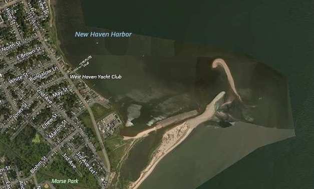
It was on a Saturday in 1957 that father took The Boy for a walk out onto Sandy Point. It seemed to the five-year-old that they walked forever, out on the spit of sand that extended a half mile out into New Haven’s inner harbor. No great lessons were taught that day, but the memory of that event was a strong one, perhaps because The Boy never repeated that trip.
Decades passed; and then one day as The Boy was sitting in a traffic jam on Long Wharf, he spotted the sand bar and began to wonder how it came about and what was significant about it. Father was no longer around to answer his questions, so he turned to others.
Two coastal geologists from SCSU and a couple of local naturalists have been very helpful in providing background information. It is suggested by some that Sandy Point has been in existence for thousands of years. Early maps of the area show its outline in 1700 and beyond. In addition, aerial images have helped us to observe the changing shape of Sandy Point over the last eighty years. It is also suggested that beneath the sand bar, there may be a layer of glacial till—assorted materials left over from the last ice age—possibly forming a sort of foundation.
What other forces have brought the sand bar to this spot, and created its odd shape? Not Old Field Creek, which enters the harbor at a spot adjacent to the sand bar. It is a very small tidal estuary, and more than likely, this backwater marsh is a site of fine sediment which has been washed in by the tides. Probably not the West River, which flows slowly into the harbor, and deposits very fine sand or silt at its mouth.
It appears from all evidence that Sandy Point was built by along-the-shore sand movement caused by wave action from the South-Southwest. All of West Haven’s beaches are artificially nourished by truckloads of sand every few years, and some of that sand eventually finds its way to Sandy Point.
It should be noted and understood that the waters nearest to Sandy Point are only 1-3 feet deep at low tide, and that the sand bar, plus the stone jetty at its tip pose a navigational hazard to careless boaters: the jetty itself is submerged at high tide.
To be continued-